A interim option for an Auckland Harbour Bridge footpath and cycleway?
Wed, April 21, 2021 |With recent news describing plans for the Northern Path (aka Skypath) as “dead in the water”, the time seems right to be thinking creatively about how we can move pedestrians and cyclists across the Waitemata.
This post outlines a potential option to add separate walking and cycling paths to either side of the Auckland Harbour Bridge as an interim option for the Northern Path until a permanent long-term solution is built. By using minimum acceptable standards for interim facilities, it appears cycling and walking links can be added quickly and easily, without removing lanes or adding new structures to the existing bridge.
To be clear, while I am a transport professional, I’ve not been involved in this project. However, I do know a lot of thinking goes into projects behind the scenes, and I’ve no doubt there are a lot of details I may not be aware of. At my company, MRCagney, we are transport planners and urban designers, not design engineers or structural engineers. But I’m interested to hear what engineers think of this idea. Namely, do people suppose this is a possible interim option while a permanent solution is developed?
Walking and cycling across the Auckland Harbour Bridge: the story so far
A business case prepared by Beca for Waka Kotahi NZTA early last year outlined a list of twelve options for getting cyclists and pedestrians over the bridge. The details of that business case can be read here.
These options were variations on five approaches to the problem:
- New shared path on the existing structure: Hang a new shared path structure under one of the clip-ons (the Skypath Trust plan), or otherwise attach it to another part of the bridge above or below deck level.
- Widen the clip-ons: Widen one or both of the clip-ons with a structural extension, to add the shared path at the existing deck level.
- New shared path structure sharing the existing foundations: Build a new bridge for walking and cycling that is supported from the existing foundations, a repeat of the same way the clip-ons were cantilevered off the old foundations.
- Entirely new shared path bridge: Build a new, and structurally separate, bridge with its own foundations alongside the Harbour Bridge.
- Take a traffic lane: Reduce the number of general traffic lanes from eight to seven, and use the space for a shared path.
Above: The proposed, and no-longer viable, pathway across the Auckland Harbour Bridge (source: Waka Kotahi NZ Transport Agency, 2019)
Through reading the business case, reports in news media, and following industry gossip, we can follow the progression of the design issues through these options. In essence, it appears the favoured option has shifted from options 1 to 4 over time, as design difficulties and engineering issues have been worked through.
The current proposal: a second harbour bridge... eventually
The current plan has landed on the idea of building a new bridge for walking and cycling.
Compared to the other options, this seems the least technically challenging approach... but being technically straightforward doesn’t mean it will be quick or cheap. At the end of the day, this approach amounts to simply building a second harbour bridge, and there is no cheap or fast way to do this, regardless of the width. It seems Waka Kotahi agrees, as media rumours of the inclusion of bus lanes and traffic lanes swirl. The fact is, a harbour bridge with one or two lanes for active modes will cost almost as much as one that has four of five lanes, so you might as well improve the public transport and roading networks at the same time.
A purpose-built bridge taking walking, cycling and public transport across the harbour, leaving the existing bridge to carry vehicle traffic, would be a great outcome. However, there are two big issues with this latest approach. Firstly, a new bridge will undoubtedly cost far more than the current budget, and, secondly, it will take a very long time to build. This has now become a transport infrastructure megaproject. This is not necessarily a problem in the long run, the greater cost will come with far greater benefits, and the longer timeframe will leave us with infrastructure that will continue to serve the city for generations.
But in the short run, it realistically means another ten years or more without any way to walk or cycle across the harbour.
Take a lane in the interim?
This, then, looks like Auckland needs an interim option while the permanent solution is being developed.
I’m not the only one to come to this conclusion, a campaign is already underway to push on with the Business Case’s fifth approach immediately, and take a traffic lane from the bridge for walking and cycling until the new crossing is opened. Cycling advocacy group Bike Auckland reports that “while a long term solution is desperately needed, in the short term, cyclists need to be given a lane on the Harbour Bridge to use.”
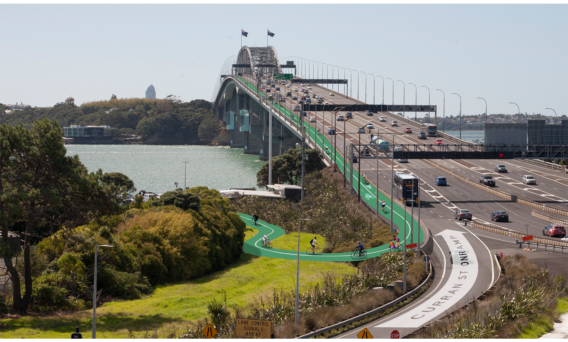
Above: Bike Auckland's image of what taking a harbour bridge lane could look like (Source: Bike Auckland)
I agree with the sentiment, and the benefit of taking a traffic lane is that it is technically simple and avoids the need for any major engineering and design work. The impacts on traffic would be minimal, as the bridge has more capacity than its approaches, and the movable barrier system allows a great deal of operational flexibility. This is the approach that Auckland Transport has taken in a number of places, for example the Northwestern Cycleway was extended along Ian McKinnon Drive by taking one of the four traffic lanes. As those four traffic lanes weren’t actually being used to their capacity, there has been no measurable impact on congestion in the street. Meanwhile, cycleway usage shot up markedly with the new safe and direct route to the city. The same approach of taking a lane on bridges for cycling is being progressed around the world, with notable examples in Vancouver and now in New York.
Nonetheless, while taking a lane is technically very quick and easy, I can see it being politically very difficult. Perhaps I’m a cynic, but I just cannot see government agencies quickly agreeing to take a lane off Stage Highway 1, regardless of what the data says or however many international examples are pointed to. The irony is that the fastest and easiest solution to the Northern Path problem could take years of public discourse to be accepted by the community.
An interim ‘minimum standard’ Northern Path?
So, then, is there an alternative option? To work in the short term, I think an interim walking and cycling crossing needs to meet four constraints:
- No new structures or extensions or significant weight added to the bridge, to be technically viable and affordable as an interim facility
- Work within the existing road designation, to avoid issues with planning and consents creating long delays.
- No reduction in the number of lanes, to be able to proceed politically on a short timeframe.
- Meet the minimum standards for safe operation of walking, cycling and general traffic and remain functional for a ten-year lifespan.
In effect, a viable interim Northern Path would need to be accommodated on the existing bridge deck without building any major new structure or removing traffic lanes. Can this be done? I think so, by working with the minimum acceptable standards for a temporary facility. Let’s work through the numbers of what minimum standards mean.
For traffic, the Austroads design standard sets the recommended width for motorway lanes at 3.5m, plus shoulders. However, this ideal standard is often reduced further where constraints exist, down to a minimum standard of 3.1m per lane. We see this all over Auckland’s motorways already: where State Highway 1 bridges over Khyber Pass; where ten lanes were squeezed in around Gillies Ave; the extra lane approaching the Ellerslie interchange; some of the ramps through Spaghetti Junction; and not least the central four lanes of the harbour bridge itself. In all cases, the motorway lanes have been reduced to the minimum standard of 3.1m wide, with a small shoulder on the outside. The fact that the harbour bridge has an 80km/h speed limit, and that it has broad emergency shoulders between the clip on lanes and the centre lanes along most of its length, supports the use of lane widths that are less than the standard for 100km/h motorways.
For walking and cycling, the minimum standard for a bidirectional path is 3.0m where it is shared by pedestrians and cycling. However, the Auckland Transport cycle engineering design code allows a narrower minimum standard for interim cycling infrastructure intended to be used for up to fifteen years. In this case, the minimum width for a bidirectional cycleway is 2.6m. However, this is for a cycleway only and not a shared path. So with a minimum 2.6m cycleway, a second separate path would also have to be provided for pedestrians.
The proposal: a minimum standard path each side
Separate cycling and walking paths form the basis of my interim Northern Path proposal: separate bidirectional paths for walking and cycling can be added to each side of the harbour bridge without widening. This is achievable on the existing clip-on deck by using minimum-standard walking and cycling widths, narrowing the traffic lanes to the minimum standard in use across Auckland, and careful design of the buffers and barriers. This would make the paths slightly wider than the facilities on the Sydney Harbour Bridge, which has a footpath on one side and a bidirectional cycleway on the other, each 2.5m wide.
The clip-ons are 9.8m wide each, with 3.5m marked lanes and relatively broad buffers and barriers either side. Using the slimmer barrier dimensions shown in the appendix of the Northern Path business case, in combination with the minimum lane standards above, retaining two lanes and adding the new traffic barrier would leave 2.3m for the cycleway or footpath, just shy of the minimum standard.
To meet the 2.6m minimum standard, a new external barrier and anti-jump screen on the outside of the bridge could be bracketed to extend 300mm beyond the existing edge of each clip on. I’m assuming this extension is small enough that it could be dealt with in the design of how the barrier attaches to the deck, rather than requiring a true structural extension of the deck itself. Because any vehicle collisions would be dealt with by the inner traffic barrier between the traffic lanes and the path, this outermost barrier is only needed to keep people on the bridge, and can be relatively light. I imagine the wind loadings will actually be the main factor, they’ll be greater than any impact from a cyclist or jogger could be.
So, to summarise, each clip on would have the following configuration from the inside out:
- 250mm barrier against the arch structure (central section) or emergency shoulder
- 300mm inside shoulder
- First 3.1m traffic lane
- Second 3.1m traffic lane
- 300mm outside shoulder
- 435mm TL4 traffic barrier with an anti-throw screen
- 2.6m bidirectional cycleway (west side) or 2.6m bidirectional footpath (east side)
- 300mm person-barrier with anti-jump screen, on a cantilevered bracket
The below sketches show this arrangement for the clip-ons, I’ve adapted these from diagrams drawn by Beca that were published in the WK business case linked above. This concept seems like a viable interim solution: It should require no significant structural additions and there should be very minimal additional weight and loads added to the structures. As well as retaining all motorway lanes, this approach would result in an arguably better arrangement for active modes by separating cyclists on one side of the bridge from pedestrians on the other. Furthermore, because the cycling and walking paths fit on the existing bridge deck, rather than being attached alongside or underneath, this means the approach routes on either side are much simplified.
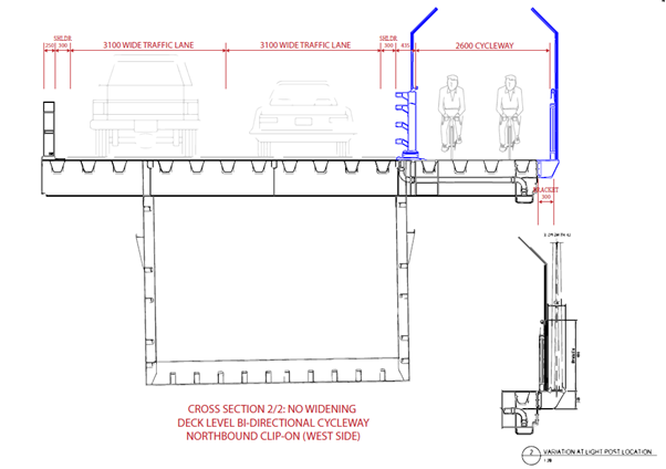
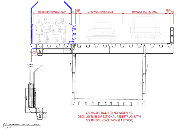
Above images show a potential northbound clip-on with bidirectional cycleway (upper harbour side) and southbound clip-on with bidirectional footpath (city side)
Overall, this interim approach could be a very effective way of quickly adding cycling and walking links across the harbour bridge. While the dimensions are less than ideal, they all still meet acceptable minimum standards and could be delivered without any widening or new structures. With low costs and minimal impacts, this could be an appropriate trade-off to last a decade until a new harbour crossing is completed.
This is an idea I’m interested in people’s opinions on. Please share your thoughts by getting in touch with me.
You can email Nic on nreid@mrcagney.com