Improving walkability to rapid transit
Thu, July 8, 2021 | Walking and CyclingThis post from Malcolm McCracken, a Transport Planner at MRCagney, was originally posted on LinkedIn.
How far are you willing to walk to access your nearest public transport stop? How much extra distance are you covering, because the most direct link isn’t there? Maybe this infuriates you every day, or maybe you’ve never considered it. Either way, this small question has huge implications for how many people can access our public transport network.
Recently, I was delighted to present at the Transportation Group Conference 2021. As the theme of the conference was ‘decarbonising transport’, my presentation discussed improving walkability to rapid transit (public transport that operates on its own right of way or corridor like a rail line or busway). This article covers what I presented in slightly more depth, and is the starting point for a series of posts around this topic.
The case for improving walkability to rapid transit as a means to support decarbonising transport is a simple argument.
- To reduce emissions from transport, we need to reduce the distance and amount that people drive.
- As well as shorter trips or working from home, a major part of the picture has to be achieving mode shift to low or zero emissions modes like public transport, walking and cycling.
- The rapid transit network is the backbone of our public transport network. Making it easier to access stations will increase the number of journeys people are likely to make using public transport instead of driving, and thus reduce emissions.
So why improve walking?
In short, walking is the most efficient way to get people in the immediate 10-minute or 800m walking catchment to the station as there is no capital cost to the vehicle storage challenge (unlike bikes and cars) or operational cost (unlike buses) for the local transport authority. This is not to say that driving, biking and feeder buses don’t have a role to play in getting people to rapid transit stations, but improving the ability for people to walk to the station should be the priority.
Locating more people close to rapid transit
Improving walkability to rapid transit is also critically important considering the recent National Policy Statement on Urban Development (NPS-UD). The NPS-UD requires councils to enable at least 6 storey development within a (minimum) 10-minute walking catchment of all rapid transit stations. Allowing higher density development has the potential to place thousands of new residents within a short walk of our rapid transit network, meaning residents are less dependent on private cars, not just for commuting but also for education, social, and health related travel. In short, the NPS-UD is a great climate change policy which hinges on access to rapid transit.
This article uses 800m catchments to explain worked example of interventions, this is the distance is how far the average person can walk in 10 Minutes. However, it should be noted that there is a significant amount of research, including by Auckland Council, showing that bigger catchments are applicable for Rapid Transit as the frequency and right of way make it more attractive than standard public transport services, meaning people are willing to walk further to access it. In fact, the NPS-UD guidance suggests 800 metres is the minimum catchment that councils should use. Ultimately, there is a spectrum of propensity to walk to Rapid Transit. The closer you are, the more likely you are to use the service, while some individuals may be willing to walk significantly further than others. Reducing the distance people have to walk will increase the likelihood of them using the Rapid Transit service.
What about the basic infrastructure?
This article does not discuss the need for good footpaths and the ability to cross roads easily. Although this is extremely important to allowing for equitable access to rapid transit this article is focused on the concepts of permeability and relative directness.
Permeability and relative directness
Permeability refers to the directness of links and the density of connections in a transport network. Relative directness is about making the route for active modes more direct - and therefore easier - than driving.
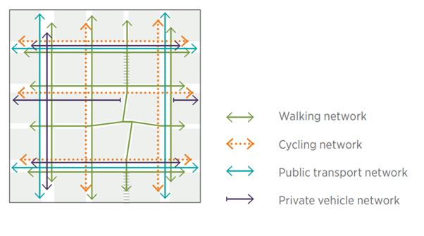
Image Source: Urban Road and Street Design Guide - Auckland Transport
In short, improving relative directness requires creating new pedestrian connections to make walking journeys more direct. In the case of accessing rapid transit stations, I have split interventions can be split into two areas: Alignment of station design with the walking network; and creating new pedestrian links through street blocks to improve the walking network. Interventions to improve relative directness can also have the benefit of increasing the walking catchment for a station. This is important with regards to my previous comment about the NPS-UD.
So, where to start?
There is no better place to start than the location of the station entrances. This is something that lies directly within the public transport authorities’ control. Station entrances also lie at the centre of the walking catchment and can be high impact because they can improve access for a significant portion of the catchment and journeys. An intervention in the street block on the edge of the catchment will only improve the walking journeys for the people walking to the station from beyond the intervention.
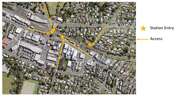
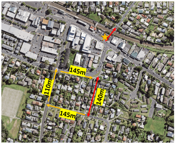
If we use Glen Eden Station in west Auckland as an example, we can see people coming from the east have to walk further along the road to get onto the outbound platform and then go around further to get to the citybound platform. So, to improve pedestrian access, we could open a new entrance on the southeast corner with a new pedestrian overbridge to make it easier and faster to get to the station.
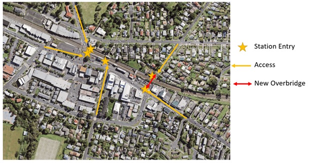
What difference does this make?
Based on where property boundaries to the road/walking network are, this new connection would deliver a 150m time saving for walking to the station for all the properties shown in green to the east of the station.
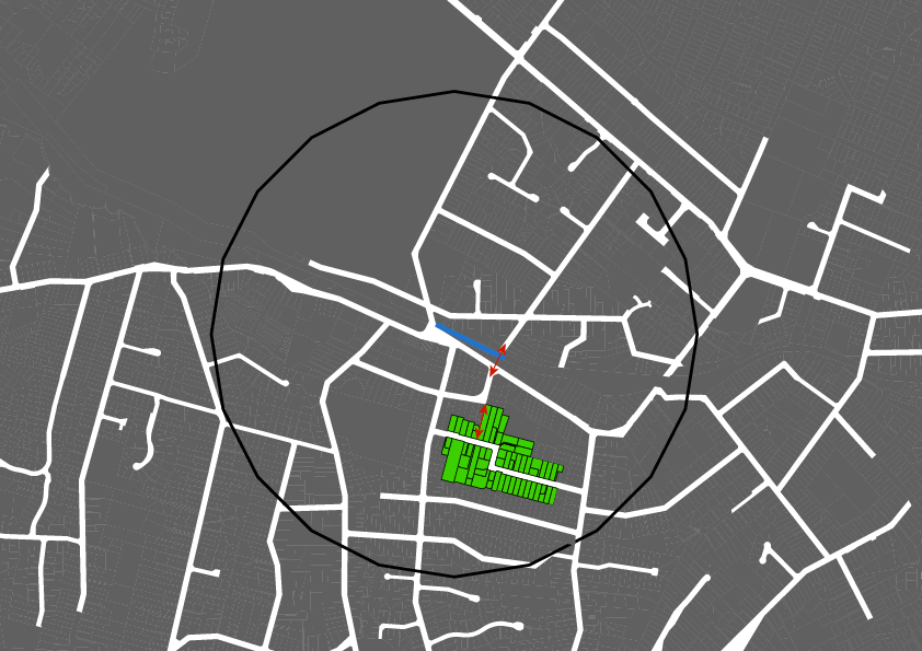
More impressively, the properties shown in orange on this map were previously outside the 800m walking catchment. Not only does this create new potential Rapid Transit customers but it opens up 4.9 hectares of new development potential. Under the NPS-UD, councils are required to enable at least 6 storey development in this area.
How this land would be developed would be down to the decision of many developers over time. However, if developed to 6 stories at 50% site coverage, this could be 1170 new, 75m2 apartments with around 2500 new residents within the catchment.
Improving permeability through street blocks
Subdivision patterns in Auckland have historically been ad-hoc outside of the central isthmus, as land transitioned from rural to suburban. This means we have some particularly large street blocks that can add a detour of hundreds of metres to any journey, which impacts walking most significantly out of all modes due to lower speeds. The image below shows how a fine gridded network better supports walking for all journeys, including to rapid transit, by allowing you to walk more directly to your destination. Improving permeability requires adding new connections for walking through larger street blocks.
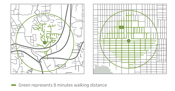
Image Source: Urban Road and Street Design Guide - Auckland Transport
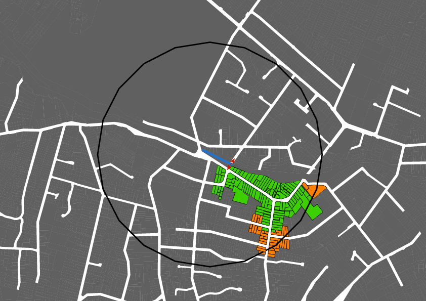
Again, we will use Glen Eden as an example. Let us see what would happen if we added a new connection through the street block to the south of our proposed new entrance, as indicated below.
The properties indicated in green below, get a 260m from the combined interventions in the street block and with the new station entrance. While this does not extend the 800m catchment, it does deliver the 260m saving to approximately 6.5 hectares of property. While this currently may only be a few hundred residents, with increased density over time as new development occurs, it can benefit hundreds more residents. Again, applying some rough estimates, if this area was to be built out at 6 storeys, it could be over 1500 new 75m2 apartments. This could house over 3000 new residents within a 10-minute walk of the train station.
Repeat
Repeating this intervention in the subsequent street blocks will continue to improve journey times across the catchment. As multiple interventions are implemented, they work together to create entire new walking routes to the station and extend the walking catchment.
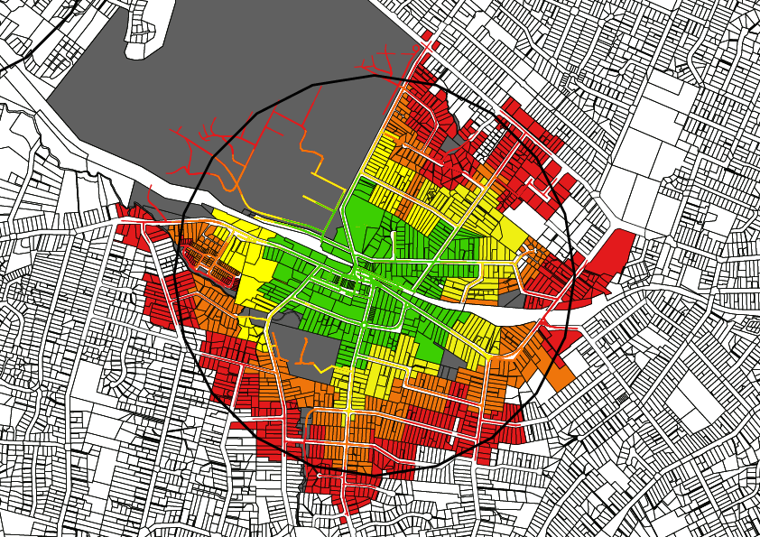
Below is a diagram of the walking catchment of Glen Eden Station with no interventions and scaled catchments to highlight the impact of the street network. Of particular interest is parcels highlighted in red within the 800m straight line catchment. The shortest route from these properties to the station are longer than 800m but have potential to be brought under 800m with interventions. The closer the red (and orange) parcels are to the centre of this catchment highlights where the street network creates particularly indirect journeys.
How do we actually implement this?
These examples show the benefit of making it more direct and easier to walk to rapid transit. While station design is something that lies within the control of the public transport authority and can be addressed over time with station upgrade projects (such as platform extensions for 9-car trains), improving permeability through street blocks is more complex. It is easy to draw a line on a map, but actually making these changes requires a little more effort.
In a future post(s) I will discuss the different approaches we can take to this. These will include how we could change the Unitary Plan to leverage private development, how we could prioritise a programme buying out existing landowners and how we could undertake large scale redevelopment projects to deliver coordinated Transit Oriented Development.
It also raises the question, one which I would like to put to readers ahead of the follow up posts, of whether we should be using straight line catchments for the implementation of zoning changes under the NPS-UD and over time look to maximise the walking catchment through improvements to the walking network.